A warehouse expansion near the Ohio River got delayed six weeks last spring because the geotech report missed a 15-foot-deep clay-filled karst depression. The contractor hit it with the first caisson. Louisville sits on limestone that dissolves into sinkholes, pinnacles, and erratic bedrock—standard borings alone won't catch it all. We run Vertical Electrical Sounding (VES) to map the resistivity contrast between clay, limestone, and water before you mobilize heavy equipment. A CPT test gives you tip resistance and sleeve friction at point locations, but VES images the continuous profile between boreholes, which matters when bedrock can drop 30 feet across a building footprint. Our field crews have worked sites from Butchertown to Jeffersontown and understand how the Louisville aquifer and Ohio River alluvium affect subsurface resistivity.
Resistivity imaging in Louisville karst isn't about finding water—it's about finding the voids before they find your foundation.
Our approach and scope
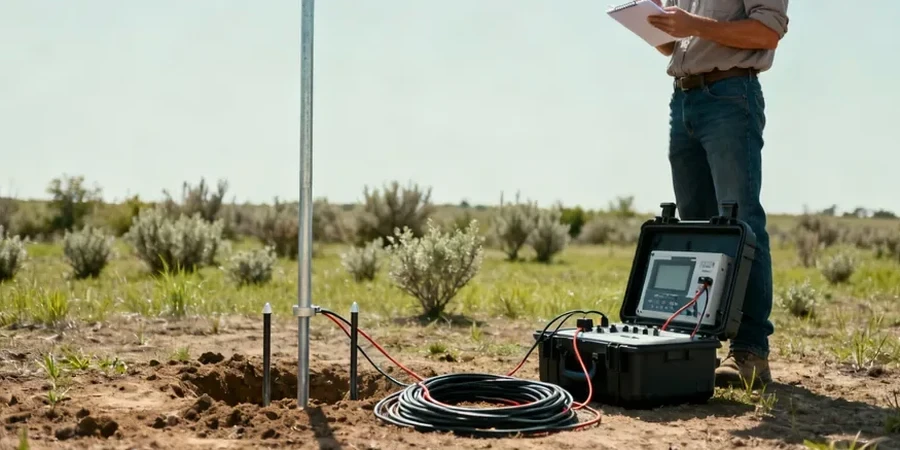
Local geotechnical context
Louisville's climate swings from wet springs with Ohio River flooding to dry late-summer months where near-surface clay shrinks and desiccates. That seasonal moisture cycle changes shallow resistivity by 30 to 40 percent, which is why we never run VES within 48 hours of heavy rain if the goal is bedrock mapping. Karst features—sinkholes, solution channels, pinnacled rock—are the primary geohazard across Jefferson County. A resistivity low can indicate a clay-filled sinkhole, or it can indicate a water-filled cavity, and the remediation costs differ by an order of magnitude. Without resistivity data, you're effectively blind to what's between your boreholes. The IBC Chapter 18 requires adequate subsurface exploration; VES combined with targeted drilling satisfies that requirement without over-drilling the site.
Applicable standards
ASTM D6431-18 Standard Guide for Using the Direct Current Resistivity Method, IBC Chapter 18 Soils and Foundations, ASCE 7 Minimum Design Loads for Buildings and Other Structures
Complementary services
VES Depth Profiling for Foundation Design
We map bedrock topography and identify low-resistivity karst features beneath proposed footings, mat foundations, and pile groups. Typical line spacing is 15 to 30 m across the building footprint, with AB/2 increments selected to resolve the top-of-rock interface within 2 m. Deliverables include 1D sounding curves, 2D resistivity pseudosections, and a geotechnical interpretation memo cross-referenced to any available boring logs.
Groundwater and Contaminant Plume Mapping
For sites with suspected groundwater contamination or where dewatering is planned, we run dense resistivity grids to delineate the water table and map conductive contaminant plumes. We integrate VES data with in-situ permeability tests where needed. Turnaround is typically 3 to 4 business days from field completion to final report.
Typical parameters
Common questions
How much does a VES survey cost for a typical Louisville commercial lot?
A standard VES survey on a one-acre commercial lot in Louisville runs between US$570 and US$1,080, depending on the number of soundings, the maximum depth required, and site access conditions. Sites with heavy vegetation, steep slopes, or adjacent power lines may require additional setup time. We provide a fixed-price quote after reviewing your site plan and geotechnical objectives.
How deep can VES investigate in Louisville's karst geology?
With a Schlumberger array and AB/2 spacing of 150 m, we typically achieve investigation depths of 50 to 100 m, depending on the resistivity contrast between layers. In Louisville's karst terrain, the strong contrast between conductive clay (below 50 ohm-m) and resistive limestone (above 500 ohm-m) actually improves depth resolution compared to more homogeneous geology. We'll specify the achievable depth in your survey plan before fieldwork begins.
Do I still need boreholes if I run a VES survey?
Yes—VES complements boreholes but does not replace them. Resistivity gives you continuous subsurface imaging between drilling points, which is critical for detecting karst features that a boring might miss by a few feet. We recommend at least one calibration borehole per site to tie resistivity values to actual lithology. The IBC requires borings for foundation design; we use VES to reduce the total number needed and to target them intelligently.